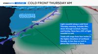
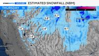
The chance is small, but light snow could fall in Reno early Thursday morning as a front moves through the region. Snow totals will be less than six inches in north central and eastern Nevada where odds are the highest. This will be a fast moving front, but it will leave a lot of cold air in its wake. A hard freeze is even possible Friday morning.

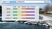
Roads will be wet in Reno for the Thursday morning commute, with most of the snow accumulating on grassy areas. I-80 east of Fernley could be slick though.

The front will move through at the surface, with an upper level low sliding past us to the north. The center of the upper level low will be too far away to give Reno a good chance for snow, but the odds are not zero. This is a slider type system, since it will be missing the Tahoe basin and traveling overland, but it is not your classic inside slider, because the low is too far away from Reno. Moisture will be torn apart as the front moves over northern Nevada, with lingering moisture closer to Winnemucca and Elko.
An inside slider is a type of storm that gives the valley a better chance for rain or snow than the Tahoe Basin. However, moisture will be lacking this time around, so snow totals will be minor. Plan on it being windy on Wednesday with gusts around 50mph in wind prone areas.
It will be cold enough for snow if any precipitation does fall in the valley Thursday morning. Overnight lows will be in the 20’s and low 30’s Thursday morning in the Truckee Meadows, and the airport is the warmest location. The snow will stick to grassy areas overall, but the higher elevations of Elko County could be slick.


There is a better chance for snow in northeast Nevada compared to Reno Thursday morning, because they are closer to the low itself. The moisture is also greater north of I-80.
Visibility along I-80 east of Reno could be low Thursday morning as the wind blows around the light snow. Conditions will improve quickly, as the snow moves along the front itself.


Gusty winds are the other side of this system. There will be more wind than anything else in Reno, Carson City, Fallon, and Fernley on Wednesday. Wind gusts will top 30mph, and wind prone areas could see wind gusts in the 50’s. The wind machine will be cranked on high by Wednesday afternoon, as the front gets closer. Once the front passes through wind speeds will ease.
It will still be breezy on Thursday, gusting in the 20’s and making it feel quite chilly for April. A Wind Advisory is up for the Western Basin and Range from 2pm Wednesday through 7am Thursday, including Pyramid Lake, where wind gusts could reach 45mph.