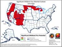
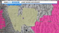
...LAKE WIND ADVISORY REMAINS IN EFFECT FROM 11 AM THIS MORNING TO
11 PM PDT THIS EVENING FOR WASHOE LAKE AND TOPAZ LAKE...

* WHAT...Southwest winds 20 to 30 mph with gusts up to 45 mph for
Washoe Lake and Topaz Lake.

* WHERE...Greater Reno-Carson City-Minden Area.

* WHEN...From 11 AM this morning to 11 PM PDT this evening.

* IMPACTS...Small boats, kayaks and paddle boards will be prone to
capsizing and should remain off lake waters until conditions
improve.

PRECAUTIONARY/PREPAREDNESS ACTIONS...

Check lake conditions before heading out and be prepared for a
sudden increase in winds and wave heights. Consider postponing
boating activities on the lake until a day with less wind.

&&